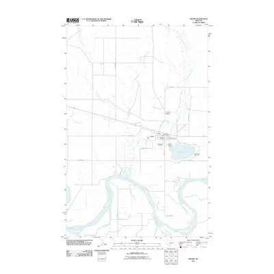
2011 Map of Frazer
USGS Topo · Published 2011About this map
The Missouri River winds along the southern edge of this landscape, anchoring a region defined by the small settlement of Frazer. At the heart of the community, the Frazer Post Office and Frazer Vol Fire Company stand near the intersection of B St and Assiniboinne St. This survey captures the vital water management infrastructure of the area, including the Little Porcupine Dam and Frazer Lake Dam East, which regulate Frazer Lake. The map reveals a transition from the river bottomlands to the surrounding plains, where the West Fork Charley Creek and East Fork Charley Creek converge. Local heritage is preserved at Sunset Rest Cemetery and Saint Joseph Cemetery, both situated just outside the town center, providing a clear record of the district's social and geographic organization.
Find a feature on this map
24 named features on this map. Tap any name to fly to it.
Don’t see what you’re looking for? This feature index may not catch every label — zoom into the map to look around manually.
Map Details
Editions of this 2011 Frazer Map
This is the sole edition of this map. No revisions or reprints were ever made.
Other maps of this area
1915 · Frazer
USGS Topo · 1:62,500
1915 · Oswego
USGS Topo · 1:62,500
1954 · Jordan
USGS Topo · 1:250,000

1954 · Glendive
USGS Topo · 1:250,000
1954 · Wolf Point
USGS Topo · 1:250,000

1954 · Glasgow
USGS Topo · 1:250,000
1956 · Jordan
USGS Topo · 1:250,000

1957 · Glasgow
USGS Topo · 1:250,000

1957 · Glendive
USGS Topo · 1:250,000
1958 · Wolf Point
USGS Topo · 1:250,000