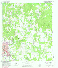
1967 Map of Fredericksburg East
USGS Topo · Published 1982About this map
Fredericksburg stands at the heart of this Gillespie County landscape, where the structured street grid of W Main St and S Adams St gives way to a terrain defined by family-named landmarks and watercourses. The eastern expansion of the town is visible alongside Barons Creek and Town Creek, with historic burial grounds like City Cem and Greenwood Cem situated near the residential core. The surrounding countryside is remarkably hilly, characterized by a series of prominent rises such as Schuetzen Hill, Henke Hill, and the Kordzik Hills, many bearing the names of early German settler families.
Find a feature on this map
53 named features on this map. Tap any name to fly to it.
Don’t see what you’re looking for? This feature index may not catch every label — zoom into the map to look around manually.
Map Details
Editions of this 1967 Fredericksburg East Map
2 editions found
Other maps of this area

1894 · Fredericksburg
USGS Topo · 1:125,000

1954 · Llano
USGS Topo · 1:250,000

1955 · Llano
USGS Topo · 1:250,000

1956 · Llano
USGS Topo · 1:250,000

1961 · Stonewall
USGS Topo · 1:24,000

1961 · Cave Creek School
USGS Topo · 1:24,000

1963 · Cain City
USGS Topo · 1:24,000

1964 · Oak Crest Park
USGS Topo · 1:24,000
1967 · Cherry Mountain
USGS Topo · 1:24,000

1967 · Fredericksburg East
USGS Topo · 1:24,000