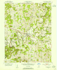
1953 Map of Fredericksburg
USGS Topo · Published 1954About this map
Fredericksburg sits at a primary crossing of the Blue River, serving as a central hub for the small agricultural communities of southern Washington and northern Harrison Counties. The river's winding course creates distinct alluvial flats such as Whittman Bottom, Walk Bottom, and Kay Bottom, which historically provided the most fertile grounds for local farmers. The rugged terrain surrounding these bottoms is marked by numerous named peaks and ridges, including McIntosh Hill, Greene Mill Hill, and Wildcat Knob.
Find a feature on this map
45 named features on this map. Tap any name to fly to it.
Don’t see what you’re looking for? This feature index may not catch every label — zoom into the map to look around manually.
Map Details
Editions of this 1953 Fredericksburg Map
2 editions found
Other maps of this area

1946 · Depauw
USGS Topo · 1:24,000

1947 · Hardinsburg
USGS Topo · 1:24,000

1948 · Milltown
USGS Topo · 1:24,000

1949 · Hardinsburg
USGS Topo · 1:24,000

1950 · Salem
USGS Topo · 1:24,000

1950 · Becks Mill
USGS Topo · 1:24,000

1950 · Palmyra
USGS Topo · 1:24,000

1953 · Fredericksburg
USGS Topo · 1:24,000
1954 · Crandall
USGS Topo · 1:24,000

1956 · Vincennes
USGS Topo · 1:250,000