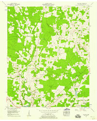
1956 Map of Fredonia
USGS Topo · Published 1958About this map
Duck River and its numerous tributaries, including Boiling Spring Branch and Greenbrier Creek, dominate this mid-century landscape in Coffee County. The area is defined by the Tennessee Valley Divide, which separates the watersheds while small agricultural settlements like Fredonia and New Union anchor the rural community. This map is particularly valuable for genealogists, as it identifies over a dozen family and community burial sites, from the Robinson Cem in the north to the Garden Cem near Green Lake.
Find a feature on this map
53 named features on this map. Tap any name to fly to it.
Don’t see what you’re looking for? This feature index may not catch every label — zoom into the map to look around manually.
Map Details
Editions of this 1956 Fredonia Map
4 editions found
Other maps of this area

1893 · Mc Minnville
USGS Topo · 1:125,000

1895 · Mc Minnville
USGS Topo · 1:125,000

1895 · Sewanee
USGS Topo · 1:125,000

1913 · Hollow Springs
USGS Topo · 1:62,500

1936 · Ovoca
USGS Topo · 1:24,000

1936 · Fredonia
USGS Topo · 1:24,000

1936 · Manchester
USGS Topo · 1:24,000

1936 · Beech Grove
USGS Topo · 1:24,000

1936 · Petty Gap
USGS Topo · 1:24,000

1936 · Noah
USGS Topo · 1:24,000