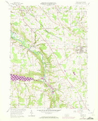
1958 Map of Fredonia
USGS Topo · Published 1972About this map
Fredonia serves as a focal point in this portion of Mercer County, situated along the B & L E railroad corridor. The landscape is defined by the winding course of the Shenango River Reservoir, which dominates the western section of the map, and smaller tributaries like Lawango Run and Mill Run. A 1970 photorevision highlights updates to the local infrastructure, including several pipelines and a telephone line traversing the township boundaries of Delaware and Jefferson.
Find a feature on this map
45 named features on this map. Tap any name to fly to it.
Don’t see what you’re looking for? This feature index may not catch every label — zoom into the map to look around manually.
Map Details
Editions of this 1958 Fredonia Map
3 editions found
Other maps of this area

1905 · Neshannock
USGS Topo · 1:62,500

1907 · Neshannock
USGS Topo · 1:62,500

1908 · Shenango
USGS Topo · 1:62,500

1911 · Stoneboro
USGS Topo · 1:62,500

1913 · Stoneboro
USGS Topo · 1:62,500

1913 · Mercer
USGS Topo · 1:62,500

1939 · Mercer
USGS Topo · 1:62,500

1943 · Mercer
USGS Topo · 1:62,500

1943 · Stoneboro
USGS Topo · 1:62,500

1950 · Cleveland
USGS Topo · 1:250,000
Featured Places
- Fairview Township, PA
- Fredonia, PA
- New Hamburg, Delaware Township
- Coolspring Township, PA
- Perry Township, PA