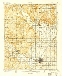
1939 Map of Fredonia
USGS Topo · Published 1939About this map
Fredonia serves as the regional hub in this late 1930s landscape, where the confluence of the Fall River and Verdigris River systems defines the terrain. The map captures a high density of rural infrastructure, particularly a vast network of country schools such as Triumph Sch, Needmore Sch, and Ten Penny Sch, reflecting the community structure of Wilson County before mid-century consolidation. Three major rail lines—the Atchison Topeka and Santa Fe, Missouri Pacific, and St Louis and San Francisco—converge here, facilitating the transport of agricultural goods from outlying settlements like Coyville and New Albany. Local landmarks such as Delaware Springs and the County Farm provide specific points of interest for genealogists tracing family locations near the many small cemeteries like Caley Cem.
Find a feature on this map
89 named features on this map. Tap any name to fly to it.
Don’t see what you’re looking for? This feature index may not catch every label — zoom into the map to look around manually.
Map Details
Editions of this 1939 Fredonia Map
2 editions found

Other maps of this area

1885 · Eureka
USGS Topo · 1:125,000

1885 · Sedan
USGS Topo · 1:125,000

1886 · Fredonia
USGS Topo · 1:125,000

1886 · Independence
USGS Topo · 1:125,000

1888 · Eureka
USGS Topo · 1:125,000

1889 · Sedan
USGS Topo · 1:125,000

1894 · Fredonia
USGS Topo · 1:125,000

1894 · Independence
USGS Topo · 1:125,000

1894 · Eureka
USGS Topo · 1:125,000

1905 · Independence
USGS Topo · 1:125,000