
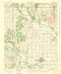
1943 Map of Fredonia
USGS Topo · Published 1943About this map
Fredonia serves as the focal point of this rural Kansas landscape, where the confluence of the Fall River and Verdigris River systems dictates the placement of settlements and transport. Surveyed in the late 1930s, the map reveals a high density of one-room schoolhouses such as Triumph Sch, Needmore Sch, and Ten Penny Sch, reflecting a deeply localized agrarian society before mid-century consolidation. A complex web of rail lines, including the Atchison Topeka and Santa Fe and the St Louis San Francisco, cross the territory to serve the river valleys. Notable landmarks like West Mound and South Mound provide topographic relief near the main town, while the presence of the Valley Gem mine and rural cemeteries like Jackson Cem offer specific touchpoints for local historians and genealogists tracing family roots in Wilson Co and Woodson Co.
Find a feature on this map
66 named features on this map. Tap any name to fly to it.
Don’t see what you’re looking for? This feature index may not catch every label — zoom into the map to look around manually.
Map Details
Editions of this 1943 Fredonia Map
2 editions found
Other maps of this area

1885 · Eureka
USGS Topo · 1:125,000

1885 · Sedan
USGS Topo · 1:125,000

1886 · Fredonia
USGS Topo · 1:125,000

1886 · Independence
USGS Topo · 1:125,000

1888 · Eureka
USGS Topo · 1:125,000

1889 · Sedan
USGS Topo · 1:125,000

1894 · Fredonia
USGS Topo · 1:125,000

1894 · Independence
USGS Topo · 1:125,000

1894 · Eureka
USGS Topo · 1:125,000

1905 · Independence
USGS Topo · 1:125,000