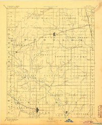
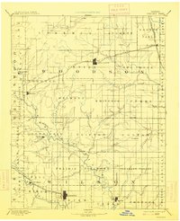
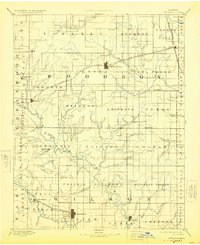
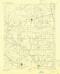
1894 Map of Fredonia
USGS Topo · Published 1904About this map
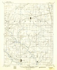
The Verdigris River and its numerous tributaries, including Buffalo Creek, carve a detailed drainage pattern across this late 19th-century landscape. Major regional centers such as Fredonia and Yates Center serve as the primary hubs, connected by a growing network of steel rails. The St. Louis and San Francisco Railroad cuts through the southern portion of the area, while the Wichita and Western Railroad traverses the north, facilitating the movement of goods and people across the prairie. Smaller, now-obscure settlements like Juse, Greystone, and Myra dot the townships, often situated near water sources or rail lines. This map highlights the early legal and social organization of the territory, with prominent township boundaries such as Center, Owl Creek, and Guilford clearly delineated. For genealogists, the placement of specific sites like New Albany and Burdgeville relative to local waterways provides essential context for homestead research.
Find a feature on this map
85 named features on this map. Tap any name to fly to it.
Don’t see what you’re looking for? This feature index may not catch every label — zoom into the map to look around manually.
Map Details
Editions of this 1894 Fredonia Map
6 editions found

Other maps of this area

1885 · Burlington
USGS Topo · 1:125,000

1885 · Eureka
USGS Topo · 1:125,000

1885 · Garnett
USGS Topo · 1:125,000

1885 · Sedan
USGS Topo · 1:125,000

1886 · Fredonia
USGS Topo · 1:125,000

1886 · Iola
USGS Topo · 1:125,000

1886 · Independence
USGS Topo · 1:125,000

1886 · Parsons
USGS Topo · 1:125,000

1888 · Emporia
USGS Topo · 1:125,000

1888 · Eureka
USGS Topo · 1:125,000