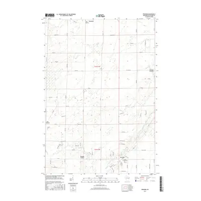
2016 Map of Freedom
USGS Topo · Published 2016About this map
Freedom serves as the central hub of this agricultural landscape in Outagamie County, situated at the intersection of several key county roads. The settlement pattern is defined by a dense network of family-named corridors such as Moore Rd and Ranch Rd, reflecting a landscape deeply shaped by rural ownership and local transit. Small rural centers like Murphy Corner, Five Corners, and Chicago Corners mark the crossroads that supported the area's farming community, while Duck Creek provides the primary drainage through the southern sections. Genealogists will find the documentation of Saint John the Baptist Cem, Freedom Cem, and the Freedom Association Cem particularly valuable for tracing local heritage. The map captures the persistent layout of township and range lines, specifically t23n r18e and t22n r18e, which continue to organize the region's development.
Find a feature on this map
65 named features on this map. Tap any name to fly to it.
Don’t see what you’re looking for? This feature index may not catch every label — zoom into the map to look around manually.
Map Details
Editions of this 2016 Freedom Map
This is the sole edition of this map. No revisions or reprints were ever made.
Other maps of this area

1954 · De Pere
USGS Topo · 1:62,500

1954 · Green Bay
USGS Topo · 1:62,500

1955 · Appleton
USGS Topo · 1:24,000

1955 · Appleton
USGS Topo · 1:62,500

1955 · Seymour
USGS Topo · 1:62,500

1955 · Green Bay
USGS Topo · 1:250,000

1974 · Seymour
USGS Topo · 1:24,000
1974 · Nichols
USGS Topo · 1:24,000

1974 · Kaukauna
USGS Topo · 1:24,000
1974 · Oneida South
USGS Topo · 1:24,000