
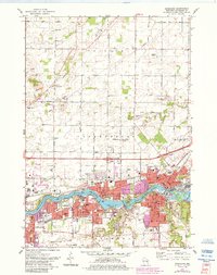
1974 Map of Kaukauna
USGS Topo · Published 1978About this map
The Fox River dominates the southern landscape of this mid-1970s Outagamie County survey, serving as the industrial and civic spine for Kaukauna, Little Chute, Kimberly, and Combined Locks. The river's complexity is revealed through specific depth and lock notations, including Normal Pool 675 and Normal Pool 683, alongside the notable Little Chute Islands. The densely developed riverfront contrasts with the agricultural patterns of Vandenbroek and Freedom to the north, where the land is partitioned by family-named routes like Coonen Road and Kelso Rd.
Find a feature on this map
95 named features on this map. Tap any name to fly to it.
Don’t see what you’re looking for? This feature index may not catch every label — zoom into the map to look around manually.
Map Details
Editions of this 1974 Kaukauna Map
2 editions found
Other maps of this area

1911 · Neenah
USGS Topo · 1:62,500

1954 · De Pere
USGS Topo · 1:62,500

1954 · Chilton
USGS Topo · 1:62,500

1955 · Neenah
USGS Topo · 1:62,500

1955 · Appleton
USGS Topo · 1:24,000

1955 · Appleton
USGS Topo · 1:62,500

1955 · Neenah
USGS Topo · 1:24,000

1955 · Green Bay
USGS Topo · 1:250,000

1974 · Hilbert
USGS Topo · 1:24,000
1974 · Oneida South
USGS Topo · 1:24,000