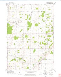
1974 Map of Freedom
USGS Topo · Published 1978About this map
The Oneida Indian Reservation Boundary bisects this landscape, separating the township of Oneida from the rural farming communities of Osborn and Freedom. In the mid-1970s, the area is characterized by a network of family-named roads like Knopp Road and Sievert Road, connecting small clusters of development at Chicago Corners and Murphy Corner. The town of Freedom serves as a local hub, featuring the Freedom Ch and the expansive VFW Memorial Park near the banks of Duck Creek. Local genealogists will find several burial grounds noted, including St John the Baptist Cem, Freedom Cem, and the Town Cem. The landscape is dotted with several industrial sites such as a Quarry and numerous Gravel Pits, indicating the importance of local mineral extraction alongside the dominant agricultural patterns.
Find a feature on this map
44 named features on this map. Tap any name to fly to it.
Don’t see what you’re looking for? This feature index may not catch every label — zoom into the map to look around manually.
Map Details
Editions of this 1974 Freedom Map
This is the sole edition of this map. No revisions or reprints were ever made.
Other maps of this area

1954 · De Pere
USGS Topo · 1:62,500

1954 · Green Bay
USGS Topo · 1:62,500

1955 · Appleton
USGS Topo · 1:24,000

1955 · Appleton
USGS Topo · 1:62,500

1955 · Seymour
USGS Topo · 1:62,500

1955 · Green Bay
USGS Topo · 1:250,000

1974 · Seymour
USGS Topo · 1:24,000
1974 · Nichols
USGS Topo · 1:24,000

1974 · Kaukauna
USGS Topo · 1:24,000
1974 · Oneida South
USGS Topo · 1:24,000