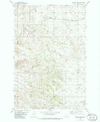
1982 Map of Freeman Creek
USGS Topo · Published 1982About this map
The Burlington Northern railroad cuts through the northern reaches of this Eastern Montana landscape, following the natural contours near Beaver Hill. This 1982 survey captures a remote drainage network defined by Freeman Creek and Hodges Creek, where the presence of numerous Spring and Springs labels suggests a critical reliance on reliable water sources in an arid grazing region. The map documents the boundary between Dawson and Wibaux counties, providing a precise record of the land division and local topography during the early 1980s. A solitary Gravel Pit in the northwest corner and the path of Glendive Spr Creek further illustrate the sparse industrial and natural features of this high plains environment.
Find a feature on this map
10 named features on this map. Tap any name to fly to it.
Don’t see what you’re looking for? This feature index may not catch every label — zoom into the map to look around manually.
Map Details
Editions of this 1982 Freeman Creek Map
This is the sole edition of this map. No revisions or reprints were ever made.
Other maps of this area

1909 · Glendive
USGS Topo · 1:250,000

1953 · Miles City
USGS Topo · 1:250,000

1954 · Glendive
USGS Topo · 1:250,000

1957 · Miles City
USGS Topo · 1:250,000

1957 · Glendive
USGS Topo · 1:250,000

1958 · Miles City
USGS Topo · 1:250,000

1958 · Glendive
USGS Topo · 1:250,000

1981 · Glendive
USGS Topo · 1:100,000

1981 · Wibaux
USGS Topo · 1:100,000
1982 · Hodges SE
USGS Topo · 1:24,000