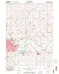
1999 Map of Freeport East
USGS Topo · Published 2000About this map
Freeport serves as the focal point of this late 20th-century survey, showing the urban expansion east toward the Pecatonica River. The town center is densely detailed with public landmarks including the Courthouse, the Armory, and several parochial institutions like St Marys Sch and St Vincent Childrens Home. The surrounding landscape in Lancaster township is a mix of agricultural plots and industrial activity, evidenced by numerous quarries and gravel pits scattered near the Yellow Creek and Smoky Hollow drainages.
Find a feature on this map
60 named features on this map. Tap any name to fly to it.
Don’t see what you’re looking for? This feature index may not catch every label — zoom into the map to look around manually.
Map Details
Editions of this 1999 Freeport East Map
This is the sole edition of this map. No revisions or reprints were ever made.
Other maps of this area

1922 · Oregon
USGS Topo · 1:62,500

1924 · Oregon
USGS Topo · 1:62,500

1932 · Pecatonica
USGS Topo · 1:62,500

1936 · Pecatonica
USGS Topo · 1:62,500

1939 · Freeport
USGS Topo · 1:48,000

1942 · Forreston
USGS Topo · 1:62,500

1944 · Freeport
USGS Topo · 1:62,500

1945 · Forreston
USGS Topo · 1:62,500

1954 · Rockford
USGS Topo · 1:250,000

1955 · Rockford
USGS Topo · 1:250,000