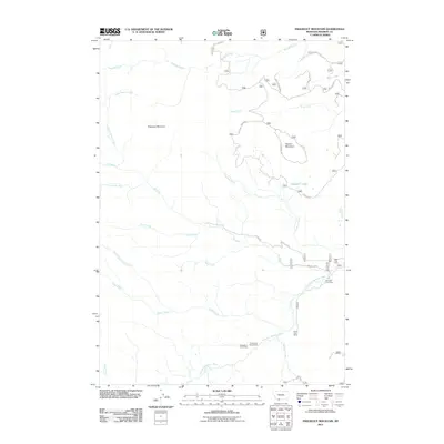
2011 Map of Freezeout Mountain
USGS Topo · Published 2011About this map
Shakelford Homestead and several livestock outposts define the human footprint in this corner of Madison County. The landscape is characterized by the high elevations of Freezeout Mountain and Flatiron Mountain, with high-altitude basins like Lower Grizzly Basin tucked between the peaks. Cattle ranching history is evidenced by the distribution of temporary settlements including Miller Cow Camp and Sloan Cow Camp along the drainages.
Find a feature on this map
30 named features on this map. Tap any name to fly to it.
Don’t see what you’re looking for? This feature index may not catch every label — zoom into the map to look around manually.
Map Details
Editions of this 2011 Freezeout Mountain Map
This is the sole edition of this map. No revisions or reprints were ever made.
Other maps of this area

1950 · Cliff Lake
USGS Topo · 1:62,500

1950 · Lower Red Rock Lake
USGS Topo · 1:62,500

1950 · Monument Ridge
USGS Topo · 1:62,500

1950 · Upper Red Rock Lake
USGS Topo · 1:62,500

1955 · Ashton
USGS Topo · 1:250,000

1958 · Ashton
USGS Topo · 1:250,000

1960 · Ashton
USGS Topo · 1:250,000
1988 · Granite Mountain
USGS Topo · 1:24,000
1988 · Bighorn Mountain
USGS Topo · 1:24,000
1988 · Hidden Lake Bench
USGS Topo · 1:24,000