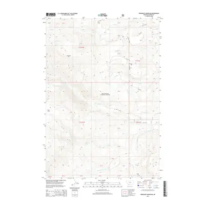
2014 Map of Freezeout Mountain
USGS Topo · Published 2014About this map
Beaverhead National Forest covers much of this high-elevation terrain in Madison County, defined by a series of prominent peaks and drainage systems. Freezeout Mtn and Flatiron Mtn anchor the central topography, while the W Fork Madison River and Elk River carve through the southern and central sections. The map reveals an interesting pattern of high-altitude flats, including Bogus Flat and Flatiron Flats, which likely served as seasonal grazing or transit points. Notable landmarks such as Grizzly Gazelle and Mossy Horn suggest the region's long-standing connection to wildlife and hunting, while the presence of Freezeout Lakes provides a primary water source in this alpine environment. The drainage network is complex, with Gazelle Cr, Soap Cr, and Tepee Cr feeding into larger river systems.
Find a feature on this map
44 named features on this map. Tap any name to fly to it.
Don’t see what you’re looking for? This feature index may not catch every label — zoom into the map to look around manually.
Map Details
Editions of this 2014 Freezeout Mountain Map
This is the sole edition of this map. No revisions or reprints were ever made.
Other maps of this area

1950 · Cliff Lake
USGS Topo · 1:62,500

1950 · Lower Red Rock Lake
USGS Topo · 1:62,500

1950 · Monument Ridge
USGS Topo · 1:62,500

1950 · Upper Red Rock Lake
USGS Topo · 1:62,500

1955 · Ashton
USGS Topo · 1:250,000

1958 · Ashton
USGS Topo · 1:250,000

1960 · Ashton
USGS Topo · 1:250,000
1988 · Granite Mountain
USGS Topo · 1:24,000
1988 · Bighorn Mountain
USGS Topo · 1:24,000
1988 · Hidden Lake Bench
USGS Topo · 1:24,000