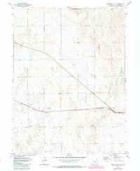
1973 Map of Fremont Butte
USGS Topo · Published 1984About this map
Xenia sits at the heart of this Washington County landscape, a small settlement defined by its position along the Burlington Northern railroad. The topography is dominated by the prominent elevation of Fremont Butte to the north, which overlooks a plain heavily marked by resource extraction. The presence of the Xenia Field is evident through numerous Oil Wells, Drill Holes, and a network of secondary roads supporting petroleum operations.
Find a feature on this map
18 named features on this map. Tap any name to fly to it.
Don’t see what you’re looking for? This feature index may not catch every label — zoom into the map to look around manually.
Map Details
Editions of this 1973 Fremont Butte Map
3 editions found
Other maps of this area

1951 · Merino SW
USGS Topo · 1:24,000

1951 · Merino SE
USGS Topo · 1:24,000

1954 · Sterling
USGS Topo · 1:250,000

1958 · Sterling
USGS Topo · 1:250,000

1973 · Akron
USGS Topo · 1:24,000

1973 · Rago
USGS Topo · 1:24,000

1973 · Fremont Butte
USGS Topo · 1:24,000

1973 · Pinneo SE
USGS Topo · 1:24,000
1973 · Buffalo Springs Ranch
USGS Topo · 1:24,000
1973 · Pinneo
USGS Topo · 1:24,000