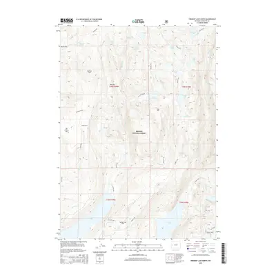
2015 Map of Fremont Lake North
USGS Topo · Published 2015About this map
Bridger National Forest dominates this alpine landscape, where the high-altitude hydrology of Sublette County is mapped in meticulous detail. The deep waters of Fremont Lake and the expansive Willow Lake anchor the southern half of the quadrangle, while a dense network of smaller basins like Trapper Lake, Gottfried Lake, and Neil Lake dot the glacial terrain. The geography is defined by a series of high parks and meadows, including Indian Park, Martin Park, and Big Rock Park, which offer breaks in the timbered slopes. Notable elevations such as Big Flattop Mtn and Pine Mtn overlook the drainage systems of Pine Cr and Trapper Cr. Access to these remote reaches is traced through established routes like the Summit Lake and Heart Lake trails, which connect the various creek parks and lakeside campsites used by generations of backcountry travelers.
Find a feature on this map
49 named features on this map. Tap any name to fly to it.
Don’t see what you’re looking for? This feature index may not catch every label — zoom into the map to look around manually.
Map Details
Editions of this 2015 Fremont Lake North Map
This is the sole edition of this map. No revisions or reprints were ever made.
Other maps of this area

1909 · Fremont Peak
USGS Topo · 1:125,000

1955 · Thermopolis
USGS Topo · 1:250,000

1955 · Lander
USGS Topo · 1:250,000

1958 · Lander
USGS Topo · 1:250,000

1958 · Thermopolis
USGS Topo · 1:250,000

1961 · Lander
USGS Topo · 1:250,000

1962 · Thermopolis
USGS Topo · 1:250,000
1964 · Cora
USGS Topo · 1:24,000

1964 · Fremont Lake South
USGS Topo · 1:24,000
1967 · New Fork Lakes
USGS Topo · 1:24,000