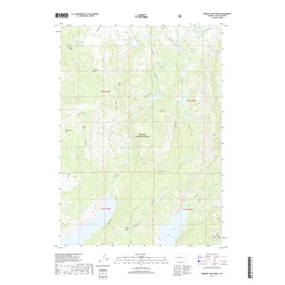
2017 Map of Fremont Lake North
USGS Topo · Published 2017About this map
Bridger National Forest defines this high-altitude landscape in Sublette County, dominated by a dense network of alpine lakes and glacial basins. The northern reach of Fremont Lake and the expanse of Willow Lake anchor the southern portion of the map, fed by high-country drainage including Lozier Cr and Deadman Cr. The terrain is marked by named meadows and clearings like Martin Park, Big Rock Park, and Indian Park, which provide rare level ground amidst the prominent rises of Pine Mtn and Big Flattop Mtn. This hydrological profile is remarkably complex, with Summit Lake and Snake Lake sitting as high-elevation collection points for numerous named creeks like Bluff Park Cr and Trapper Cr, illustrating the intricate water systems of the Wind River Range.
Find a feature on this map
53 named features on this map. Tap any name to fly to it.
Don’t see what you’re looking for? This feature index may not catch every label — zoom into the map to look around manually.
Map Details
Editions of this 2017 Fremont Lake North Map
This is the sole edition of this map. No revisions or reprints were ever made.
Other maps of this area

1909 · Fremont Peak
USGS Topo · 1:125,000

1955 · Thermopolis
USGS Topo · 1:250,000

1955 · Lander
USGS Topo · 1:250,000

1958 · Lander
USGS Topo · 1:250,000

1958 · Thermopolis
USGS Topo · 1:250,000

1961 · Lander
USGS Topo · 1:250,000

1962 · Thermopolis
USGS Topo · 1:250,000
1964 · Cora
USGS Topo · 1:24,000

1964 · Fremont Lake South
USGS Topo · 1:24,000
1967 · New Fork Lakes
USGS Topo · 1:24,000