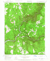
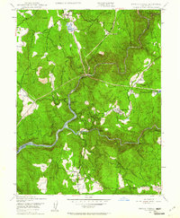
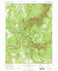
1948 Map of French Corral
USGS Topo · Published 1967About this map
French Corral and the surrounding gold-country landscapes of Yuba and Nevada Counties are captured here just after the Second World War. The terrain is defined by the deep canyons of the Middle Yuba River and the South Yuba River, which meet at Rice Crossing near the center of the map. Mining history is evident at the San Juan Mine (Abandoned) and numerous river bars like Condemned Bar and Starvation Bar. The presence of the Englebright Reservoir along the western boundary indicates the mid-century infrastructure shifts in the Sierra foothills. Local life is anchored by family-named landmarks such as the Schwartz Ranch and Richards Ranch, while educational and community centers like the Pleasant Valley Sch and a local Cem provide specific points of interest for genealogical research in these small, scattered settlements.
Find a feature on this map
41 named features on this map. Tap any name to fly to it.
Don’t see what you’re looking for? This feature index may not catch every label — zoom into the map to look around manually.
Map Details
Editions of this 1948 French Corral Map
4 editions found
Historical Maps of Birchville Through Time
50 maps found

1911 Browns Valley
Yuba County, CA

1911 Ostrom
Yuba County, CA

1912 Prairie Creek
Yuba County, CA

1915 Spenceville
Yuba County, CA

1947 Browns Valley
Yuba County, CA

1948 Challenge
Yuba County, CA

1948 French Corral
Yuba County, CA

1948 Oregon House
Yuba County, CA

1948 Strawberry Valley
Yuba County, CA

1949 Browns Valley
Yuba County, CA

1949 Camp Far West
Yuba County, CA

1949 Smartville
Yuba County, CA

1950 Challenge
Yuba County, CA

1950 French Corral
Yuba County, CA

1950 Oregon House
Yuba County, CA

1950 Strawberry Valley
Yuba County, CA

1951 Camp Far West
Yuba County, CA

1951 Smartville
Yuba County, CA

1994 Strawberry Valley
Yuba County, CA

1995 Camp Far West
Yuba County, CA

1995 Challenge
Yuba County, CA

1995 French Corral
Yuba County, CA

1995 Oregon House
Yuba County, CA

1995 Smartville
Yuba County, CA

2000 Challenge
Yuba County, CA

2000 French Corral
Yuba County, CA

2012 Browns Valley
Yuba County, CA

2012 Camp Far West
Yuba County, CA

2012 Challenge
Yuba County, CA

2012 French Corral
Yuba County, CA

2012 Oregon House
Yuba County, CA

2012 Strawberry Valley
Yuba County, CA

2015 Browns Valley
Yuba County, CA

2015 Camp Far West
Yuba County, CA

2015 Challenge
Yuba County, CA

2015 French Corral
Yuba County, CA

2015 Oregon House
Yuba County, CA

2015 Strawberry Valley
Yuba County, CA

2018 Browns Valley
Yuba County, CA

2018 Camp Far West
Yuba County, CA

2018 Challenge
Yuba County, CA

2018 French Corral
Yuba County, CA

2018 Oregon House
Yuba County, CA

2018 Strawberry Valley
Yuba County, CA

2021 Browns Valley
Yuba County, CA

2021 Oregon House
Yuba County, CA

2021 Strawberry Valley
Yuba County, CA

2022 Camp Far West
Yuba County, CA

2022 Challenge
Yuba County, CA

2022 French Corral
Yuba County, CA