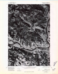
1975 Map of Frenchville SW
USGS Topo · Published 1981About this map
The St John River carves a deep valley through the international borderlands between northern Maine and New Brunswick in this 1975 orthophoto. The imagery reveals the unique long-lot land divisions characteristic of Acadian settlement patterns, where thin strips of farmland stretch perpendicular to the river's edge. Along the southern bank, the communities of Frenchville and Upper Frenchville follow the river road, while the Canadian side features St-Hilaire and Albertine. Higher elevations to the north show the denser forest and rural outposts like Colin and Verret. This specific aerial perspective provides researchers with a clear view of the mid-1970s land use, showing the transition from the fertile river bottoms to the timbered ridges in a region defined by its binational connection.
Find a feature on this map
9 named features on this map. Tap any name to fly to it.
Don’t see what you’re looking for? This feature index may not catch every label — zoom into the map to look around manually.
Map Details
Editions of this 1975 Frenchville SW Map
This is the sole edition of this map. No revisions or reprints were ever made.
Other maps of this area

1927 · Square Lake
USGS Topo · 1:48,000

1928 · Eagle Lake
USGS Topo · 1:48,000

1931 · Square Lake
USGS Topo · 1:62,500

1931 · Eagle Lake
USGS Topo · 1:62,500

1932 · Frenchville
USGS Topo · 1:48,000

1932 · Fort Kent
USGS Topo · 1:48,000

1935 · Fort Kent
USGS Topo · 1:62,500

1935 · Frenchville
USGS Topo · 1:62,500

1953 · Square Lake
USGS Topo · 1:62,500

1962 · Edmundston
USGS Topo · 1:250,000