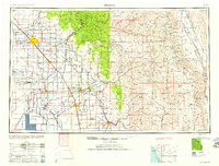
1958 Map of Fresno
USGS Topo · Published 1958About this map
The San Joaquin Valley is depicted here as a dense grid of agricultural and civic development, anchored by the growing urban center of Fresno. At this mid-century point, the valley floor is defined by an intricate network of irrigation and transport, where the Southern Pacific RR and Atchison Topeka & Santa Fe Ry connect established farming hubs like Hanford, Visalia, and Tulare. To the south, the footprint of Tulare Lake remains a prominent feature of the landscape, while the eastern horizon is dominated by the high peaks of the Sierra Nevada.
Find a feature on this map
217 named features on this map. Tap any name to fly to it.
Don’t see what you’re looking for? This feature index may not catch every label — zoom into the map to look around manually.
Map Details
Editions of this 1958 Fresno Map
This is the sole edition of this map. No revisions or reprints were ever made.
Other maps of this area
1903 · Tehipite
USGS Topo · 1:125,000
1904 · Kaiser
USGS Topo · 1:125,000
1904 · Kaweah
USGS Topo · 1:125,000
1905 · Tehipite
USGS Topo · 1:125,000
1905 · Olancha
USGS Topo · 1:125,000
1905 · Fairview
USGS Topo · 1:24,000
1906 · Kernville
USGS Topo · 1:125,000
1907 · Olancha
USGS Topo · 1:125,000
1907 · Mt. Whitney
USGS Topo · 1:125,000
1908 · Lida
USGS Topo · 1:250,000