1960 Map of Fresno
USGS Topo · Published 1960About this map
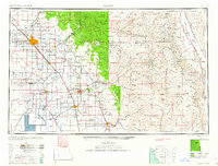
Fresno and the surrounding San Joaquin Valley are depicted here during a period of significant agricultural and urban expansion. This 1960 composite map, compiled from earlier surveys and aerial photography, illustrates the dense network of irrigation and transport that transformed the region. The interplay of the Southern Pacific and Atchison Topeka and Santa Fe railroads alongside the Visalia Electric line highlights the industrial backbone of the valley floor. To the east, the landscape shifts dramatically into the high peaks of the Sierra Nevada, featuring Mt Whitney and the protected lands of Sequoia National Park and Kings Canyon National Park. The presence of Tulare Lake at the southern edge, fed by the Kings River and Tule River, provides a critical look at the hydrology of the basin before mid-century water management projects fully altered these seasonal water bodies.
Find a feature on this map
104 named features on this map. Tap any name to fly to it.
Don’t see what you’re looking for? This feature index may not catch every label — zoom into the map to look around manually.
Map Details
Editions of this 1960 Fresno Map
2 editions found

Other maps of this area

1903 · Tehipite
USGS Topo · 1:125,000

1904 · Kaiser
USGS Topo · 1:125,000

1904 · Kaweah
USGS Topo · 1:125,000

1905 · Tehipite
USGS Topo · 1:125,000

1905 · Olancha
USGS Topo · 1:125,000

1905 · Fairview
USGS Topo · 1:24,000

1906 · Kernville
USGS Topo · 1:125,000

1907 · Olancha
USGS Topo · 1:125,000

1907 · Mt. Whitney
USGS Topo · 1:125,000

1908 · Lida
USGS Topo · 1:250,000