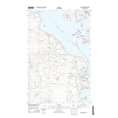
2014 Map of Friday Harbor
USGS Topo · Published 2014About this map
Friday Harbor serves as the focal point for this maritime landscape, anchored by the Friday Harbor Ferry Landing and the Friday Harbor Airport. The map captures the dense network of islands and passages that define the San Juan archipelago, from the coastal facilities at Deer Harbor Marina to the protected waters of Spring Passage. Inland, the terrain of San Juan Island is punctuated by fresh water bodies like Zylstra Lake, Sportsmans Lake, and Egg Lake, alongside the agricultural corridor of San Juan Valley. Scientific and community interests are represented by the Oceanographic Laboratories near Biological Hill and the Old American Legion Hall. The coastlines are marked by distinct landmarks such as Limestone Point and Point Caution, reflecting the varied maritime character of Puget Sound.
Find a feature on this map
150 named features on this map. Tap any name to fly to it.
Don’t see what you’re looking for? This feature index may not catch every label — zoom into the map to look around manually.
Map Details
Editions of this 2014 Friday Harbor Map
This is the sole edition of this map. No revisions or reprints were ever made.
Other maps of this area

1943 · Richardson
USGS Topo · 1:62,500

1943 · Orcas Island
USGS Topo · 1:62,500

1953 · Stuart Island
USGS Topo · 1:24,000

1954 · Roche Harbor
USGS Topo · 1:24,000

1954 · Waldron Island
USGS Topo · 1:24,000

1954 · Friday Harbor
USGS Topo · 1:24,000

1954 · False Bay
USGS Topo · 1:24,000

1957 · Richardson
USGS Topo · 1:62,500

1957 · Orcas Island
USGS Topo · 1:62,500

1957 · Victoria
USGS Topo · 1:250,000