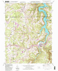
1993 Map of Friendsville
USGS Topo · Published 1999About this map
The Youghiogheny River Lake dominates the eastern portion of this tri-state borderland, where the boundaries of Maryland, Pennsylvania, and West Virginia converge. This landscape is defined by its deep drainages and ridges, including the prominent Division Ridge and Winding Ridge. The map documents a rural community structure centered on small church-and-school hubs such as Blooming Rose Ch and the McCabe Sch. The historic Mason and Dixon Line serves as the political divide between Henry Clay and Addison townships to the north and Maryland's Garrett Co to the south.
Find a feature on this map
64 named features on this map. Tap any name to fly to it.
Don’t see what you’re looking for? This feature index may not catch every label — zoom into the map to look around manually.
Map Details
Editions of this 1993 Friendsville Map
2 editions found
Other maps of this area

1900 · Accident
USGS Topo · 1:62,500

1900 · Uniontown
USGS Topo · 1:62,500

1904 · Bruceton
USGS Topo · 1:62,500

1922 · Confluence
USGS Topo · 1:62,500

1926 · Bruceton
USGS Topo · 1:62,500

1931 · Uniontown
USGS Topo · 1:62,500

1931 · Confluence
USGS Topo · 1:62,500

1931 · Bruceton Mills
USGS Topo · 1:62,500

1933 · Confluence
USGS Topo · 1:62,500

1933 · Bruceton
USGS Topo · 1:62,500