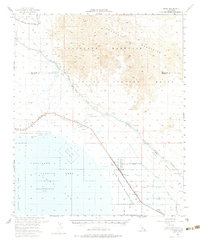
1956 Map of Frink
USGS Topo · Published 1983About this map
The Chocolate Mountains dominate the northeastern portion of this mid-century landscape, overlooking a complex intersection of military, agricultural, and recreational interests. Along the shoreline of the Salton Sea, the map identifies the Salton Sea State Park and the burgeoning community of Bombay Beach. The desert floor is heavily utilized by the Department of the Interior and military agencies, evidenced by the Chocolate Mountain Aerial Gunnery Range and a specialized Seaplane Landing Area on the water.
Find a feature on this map
40 named features on this map. Tap any name to fly to it.
Don’t see what you’re looking for? This feature index may not catch every label — zoom into the map to look around manually.
Map Details
Editions of this 1956 Frink Map
3 editions found
Other maps of this area

1940 · Kane Spring
USGS Topo · 1:62,500

1940 · Iris
USGS Topo · 1:62,500

1940 · Frink
USGS Topo · 1:62,500

1940 · Cottonwood Spring
USGS Topo · 1:62,500

1940 · Iris Pass
USGS Topo · 1:62,500

1940 · Canyon Spring
USGS Topo · 1:62,500

1940 · Durmid
USGS Topo · 1:62,500

1943 · Canyon Spring
USGS Topo · 1:62,500

1944 · Cottonwood Spring
USGS Topo · 1:62,500

1944 · Durmid
USGS Topo · 1:62,500