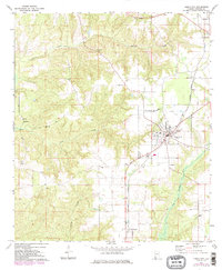
1972 Map of Frisco City
USGS Topo · Published 1984About this map
Frisco City serves as the central hub of this Monroe County landscape, where the Burlington Northern railroad corridor dictates the placement of settlements like Megargel and Mexboro. The terrain is defined by the drainage basins of Randons Creek and Bear Creek, which carve through the woodland to create a dissected topography. Rural life is anchored by numerous small congregations and their associated burial grounds, including the Lilly Ch Cem and the Bright Morning Star Ch near the local Middle Sch.
Find a feature on this map
24 named features on this map. Tap any name to fly to it.
Don’t see what you’re looking for? This feature index may not catch every label — zoom into the map to look around manually.
Map Details
Editions of this 1972 Frisco City Map
3 editions found
Other maps of this area

1953 · Andalusia
USGS Topo · 1:250,000

1957 · Andalusia
USGS Topo · 1:250,000

1972 · Monroeville
USGS Topo · 1:24,000

1972 · Frisco City
USGS Topo · 1:24,000

1972 · Frisco City SE
USGS Topo · 1:24,000

1972 · Uriah East
USGS Topo · 1:24,000

1972 · Excel
USGS Topo · 1:24,000

1972 · Mexia
USGS Topo · 1:24,000

1972 · Uriah West
USGS Topo · 1:24,000

1972 · Flynns Lake
USGS Topo · 1:24,000