
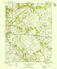
1942 Map of Fritchton
USGS Topo · Published 1942About this map
The eastern outskirts of Vincennes and the agricultural lands of Knox County define this 1942 survey, where a complex network of railroads reflects the region's industrial and transit importance. The Baltimore and Ohio RR cuts a straight path through the village of Fritchton, while the Pennsylvania RR and Chicago and Eastern Illinois RR navigate the terrain to the north and west. Local social services are prominent, represented by the County Farm, Hillcrest Hospital, and St Vincent Orphanage situated on the rise above the Kelso Creek bottoms.
Find a feature on this map
34 named features on this map. Tap any name to fly to it.
Don’t see what you’re looking for? This feature index may not catch every label — zoom into the map to look around manually.
Map Details
Editions of this 1942 Fritchton Map
2 editions found
Other maps of this area

1915 · Vincennes
USGS Topo · 1:62,500

1917 · Birds
USGS Topo · 1:62,500

1942 · Birds
USGS Topo · 1:62,500

1943 · Oaktown
USGS Topo · 1:24,000

1943 · Bicknell
USGS Topo · 1:24,000

1944 · Fritchton
USGS Topo · 1:24,000

1944 · Monroe City
USGS Topo · 1:24,000

1944 · Wheatland
USGS Topo · 1:24,000

1944 · Iona
USGS Topo · 1:24,000

1944 · Vincennes
USGS Topo · 1:62,500