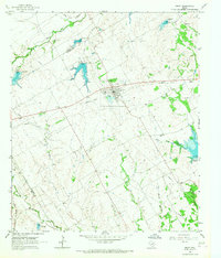
1965 Map of Frost
USGS Topo · Published 1967About this map
The town of Frost serves as the focal point of this mid-1960s survey, situated along the Old Railroad Grade and an arterial Pipeline. This rural Texas landscape is defined by its water management and complex drainage systems, featuring numerous reservoirs such as Dam No 101A and Dam No 119A. The topography is shaped by the headwaters of Richland Creek, Hackberry Creek, and Post Oak Creek, which segment the rolling prairie into distinct ranching and agricultural parcels. Genealogists and local historians will find significant value in the distribution of family-named burial grounds, including Blanton-Hooser Cem, Pevehouse Cem, and Union Hill Cem, often located near these seasonal watercourses. The presence of the Missouri Pacific railroad line in the southwest corner and the defunct rail grade through the center of town illustrates the changing transportation network of Navarro County.
Find a feature on this map
31 named features on this map. Tap any name to fly to it.
Don’t see what you’re looking for? This feature index may not catch every label — zoom into the map to look around manually.
Map Details
Editions of this 1965 Frost Map
This is the sole edition of this map. No revisions or reprints were ever made.
Other maps of this area

1954 · Dallas
USGS Topo · 1:250,000

1954 · Waco
USGS Topo · 1:250,000

1955 · Waco
USGS Topo · 1:250,000

1956 · Dawson
USGS Topo · 1:24,000

1957 · Irene
USGS Topo · 1:24,000
1957 · Malone
USGS Topo · 1:24,000

1958 · Dallas
USGS Topo · 1:250,000

1962 · Cryer Creek
USGS Topo · 1:24,000
1965 · Avalon
USGS Topo · 1:24,000
1965 · Blooming Grove
USGS Topo · 1:24,000