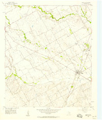
1957 Map of Malone
USGS Topo · Published 1958About this map
Malone and Bynum anchor this Hill County landscape during the late 1950s, a period defined by the agricultural rhythms of central Texas. The Missouri Pacific railroad cuts a diagonal line through the territory, serving as the primary commercial artery for these small towns. Along the winding courses of Bynum Creek, Ash Creek, and Pecan Creek, a series of artificial Levees suggests a concerted effort to manage the local watershed for farming. For the family historian, the map preserves the locations of several community landmarks, including St Peters Ch and the Salem Sch. The rural social fabric is further evidenced by several scattered burial grounds, such as Salem Cem, Walling Cem, and Graves Cem, which stand as markers of early settlement patterns before modern consolidation shifted the area's geography.
Find a feature on this map
17 named features on this map. Tap any name to fly to it.
Don’t see what you’re looking for? This feature index may not catch every label — zoom into the map to look around manually.
Map Details
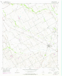
Editions of this 1957 Malone Map
2 editions found
Other maps of this area

1891 · Cleburne
USGS Topo · 1:125,000

1892 · Waco
USGS Topo · 1:125,000

1894 · Cleburne
USGS Topo · 1:125,000

1920 · Waco
USGS Topo · 1:125,000

1954 · Dallas
USGS Topo · 1:250,000

1954 · Waco
USGS Topo · 1:250,000

1955 · Waco
USGS Topo · 1:250,000

1956 · Hubbard
USGS Topo · 1:24,000

1956 · Penelope
USGS Topo · 1:24,000

1956 · Abbott
USGS Topo · 1:24,000