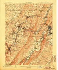
1901 Map of Frostburg
USGS Topo · Published 1906About this map
Savage Mountain and Dans Mountain define the topography of this coal and industrial region at the turn of the century. The map documents an intensive extraction landscape, marked by numbered mining districts like No. 17 and No. 24, alongside established settlements such as Frostburg and Cumberland. The transportation network is remarkably dense, showing the transition from the historic National Road and the C. & O. Canal to an intricate web of railroads including the Cumberland and Pennsylvania R. R. and the Baltimore and Ohio R. R.
Find a feature on this map
131 named features on this map. Tap any name to fly to it.
Don’t see what you’re looking for? This feature index may not catch every label — zoom into the map to look around manually.
Map Details
Editions of this 1901 Frostburg Map
2 editions found
Other maps of this area

1891 · Romney
USGS Topo · 1:125,000

1895 · Piedmont
USGS Topo · 1:125,000

1898 · Frostburg
USGS Topo · 1:62,500

1899 · Flintstone
USGS Topo · 1:62,500

1899 · Grantsville
USGS Topo · 1:62,500

1900 · Flintstone
USGS Topo · 1:62,500

1901 · Frostburg
USGS Topo · 1:62,500

1904 · Grantsville
USGS Topo · 1:62,500

1908 · Frostburg
USGS Topo · 1:62,500

1919 · Elk Garden
USGS Topo · 1:48,000