
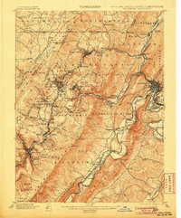
1901 Map of Frostburg
USGS Topo · Published 1901About this map
The George's Creek coal region and the transportation hub of Cumberland dominate this 1897 survey, reflecting a landscape shaped by industrial extraction and mountain transit. Mining operations are central to the local economy, clearly marked at Eckhart Mines, Borden Shaft, and Midlothian. The complex topography of Savage Mountain and Dans Mountain necessitated a dense network of rail and road, including the Cumberland and Pennsylvania R. R. and the historic Cumberland and National Turnpike. Along the Cumberland River, the C. & O. Canal follows the water's edge, illustrating the era's reliance on both water and rail. Small settlements like Vale Summit and Hoffman are positioned near these critical transport veins, providing a snapshot of the region's development before the turn of the century.
Find a feature on this map
124 named features on this map. Tap any name to fly to it.
Don’t see what you’re looking for? This feature index may not catch every label — zoom into the map to look around manually.
Map Details
Editions of this 1901 Frostburg Map
2 editions found
Other maps of this area

1891 · Romney
USGS Topo · 1:125,000

1895 · Piedmont
USGS Topo · 1:125,000

1898 · Frostburg
USGS Topo · 1:62,500

1899 · Flintstone
USGS Topo · 1:62,500

1899 · Grantsville
USGS Topo · 1:62,500

1900 · Flintstone
USGS Topo · 1:62,500

1904 · Grantsville
USGS Topo · 1:62,500

1908 · Frostburg
USGS Topo · 1:62,500

1919 · Elk Garden
USGS Topo · 1:48,000

1920 · Elk Garden
USGS Topo · 1:48,000