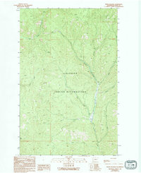
1989 Map of Frosty Meadow
USGS Topo · Published 1994About this map
Colville Indian Reservation lands dominate this landscape in Ferry County, where a complex network of mountain streams converges. The terrain is defined by the steep drainages of Bridge Creek, Ninemile Creek, and Klondyke Creek, illustrating the remote wilderness character of the Pacific Northwest in the late 1980s. The eponymous Frosty Meadow sits in a high drainage where Jones Creek meets Ninemile Creek, representing a rare opening in the dense forest cover.
Find a feature on this map
16 named features on this map. Tap any name to fly to it.
Don’t see what you’re looking for? This feature index may not catch every label — zoom into the map to look around manually.
Map Details
Editions of this 1989 Frosty Meadow Map
2 editions found
Other maps of this area

1948 · Wilmont Creek
USGS Topo · 1:62,500

1950 · Wilmont Creek
USGS Topo · 1:62,500

1952 · Keller
USGS Topo · 1:62,500

1952 · Twin Lakes
USGS Topo · 1:62,500

1953 · Seventeenmile Mtn.
USGS Topo · 1:62,500

1954 · Okanogan
USGS Topo · 1:250,000

1956 · Wilmont Creek
USGS Topo · 1:62,500

1958 · Okanogan
USGS Topo · 1:250,000

1984 · Nespelem
USGS Topo · 1:100,000
1985 · Ninemile Flat
USGS Topo · 1:24,000