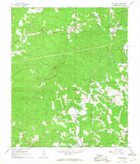
1966 Map of Fruithurst
USGS Topo · Published 1968About this map
Fruithurst and the neighboring community of Muscadine sit along the Southern railroad line in the mid-1960s, anchoring a landscape where small rural settlements and churches follow the winding course of the Tallapoosa River. This Cleburne County terrain is marked by a dense network of country roads connecting local landmarks such as Mount Olive Cem and the Oak Grove Lookout Tower. The river system, including Cane Creek and Kemp Creek, dictates the location of early communities like Abernathy and Plainview. Numerous small congregations are visible across the countryside, from Upper Cane Creek Ch in the northwest to New Hopewell Ch in the southeast. These churches, often paired with community names, serve as vital reference points for genealogists tracing family roots in this corner of Alabama before modern development altered the rural character of the region.
Find a feature on this map
28 named features on this map. Tap any name to fly to it.
Don’t see what you’re looking for? This feature index may not catch every label — zoom into the map to look around manually.
Map Details
Editions of this 1966 Fruithurst Map
2 editions found
Other maps of this area

1889 · Tallapoosa
USGS Topo · 1:125,000

1892 · Tallapoosa
USGS Topo · 1:125,000

1897 · Tallapoosa
USGS Topo · 1:125,000

1900 · Anniston
USGS Topo · 1:125,000

1953 · Atlanta
USGS Topo · 1:250,000

1957 · Atlanta
USGS Topo · 1:250,000

1958 · Atlanta
USGS Topo · 1:250,000

1965 · Tallapoosa South
USGS Topo · 1:24,000

1966 · Tallapoosa North
USGS Topo · 1:24,000
1966 · Hightower
USGS Topo · 1:24,000