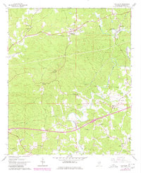
1966 Map of Fruithurst
USGS Topo · Published 1980About this map
The Southern railroad corridor anchors this pocket of eastern Alabama, connecting the hilltop town of Fruithurst with Muscadine near the state line. Originally mapped in the 1960s with updates through 1980, the sheet reveals a landscape defined by small rural communities and numerous country congregations. The winding course of the Tallapoosa River cuts through the eastern half of the map, fed by smaller tributaries like Cane Creek and Muscadine Creek. This area preserves a high density of sites for local history and genealogy, ranging from the Oak Grove Lookout Tower to a series of community centers such as Plainview, Lebanon, and Abernathy. The presence of many family-oriented landmarks, including Harmony Grove Ch, New Hope Ch, and Mount Olive Cem, reflects the established social geography of Cleburne County during this era.
Find a feature on this map
33 named features on this map. Tap any name to fly to it.
Don’t see what you’re looking for? This feature index may not catch every label — zoom into the map to look around manually.
Map Details
Editions of this 1966 Fruithurst Map
2 editions found
Other maps of this area

1889 · Tallapoosa
USGS Topo · 1:125,000

1892 · Tallapoosa
USGS Topo · 1:125,000

1897 · Tallapoosa
USGS Topo · 1:125,000

1900 · Anniston
USGS Topo · 1:125,000

1953 · Atlanta
USGS Topo · 1:250,000

1957 · Atlanta
USGS Topo · 1:250,000

1958 · Atlanta
USGS Topo · 1:250,000

1965 · Tallapoosa South
USGS Topo · 1:24,000

1966 · Tallapoosa North
USGS Topo · 1:24,000
1966 · Hightower
USGS Topo · 1:24,000