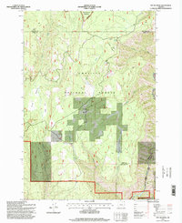
1995 Map of Fry Meadow
USGS Topo · Published 1998About this map
Pearson Cabin and Jaussaud Corral represent the human footprint within this high-elevation landscape of the Blue Mountains during the mid-1990s. The terrain is defined by a series of expansive clearings and grazing grounds, including Fry Meadow, Swikert Meadow, and Brock Meadows, which suggest a long-standing history of seasonal livestock management. The area is heavily marked by the intersections of the Umatilla National Forest and Wallowa-Whitman National Forest, with the northern border touching the Wenaha-Tucannon Wilderness. Access to these remote reaches is provided by the historical Pomeroy Walla Walla Rd and Wenaha-Tucannon Rd, which navigate the high ridges near Lookout Mountain. Small-scale industrial activity is evidenced by a Gravel Pit, likely used for maintaining the forest road network that connects these scattered mountain meadows and drainages like Sheep Creek and Proctor Creek.
Find a feature on this map
21 named features on this map. Tap any name to fly to it.
Don’t see what you’re looking for? This feature index may not catch every label — zoom into the map to look around manually.
Map Details
Editions of this 1995 Fry Meadow Map
This is the sole edition of this map. No revisions or reprints were ever made.
Other maps of this area

1955 · Grangeville
USGS Topo · 1:250,000

1959 · Grangeville
USGS Topo · 1:250,000

1964 · Partridge Creek
USGS Topo · 1:24,000

1964 · Howard Butte
USGS Topo · 1:24,000

1964 · Rondowa
USGS Topo · 1:24,000

1967 · Fry Meadow
USGS Topo · 1:24,000

1967 · Elbow Creek
USGS Topo · 1:24,000
1967 · Bone Spring
USGS Topo · 1:24,000
1967 · Deep Creek
USGS Topo · 1:24,000
1967 · Wenaha Forks
USGS Topo · 1:24,000