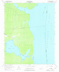
1953 Map of Frying Pan
USGS Topo · Published 1977About this map
Gum Neck defines this low-lying coastal landscape where the waters of the Alligator River and East Lake meet. Settlement is concentrated along the Frying Pan Road, leading to the small community of Frying Pan and its nearby Cem and Free Union Ch. The topography is almost entirely aquatic or marshy, with an intricate network of narrow waterways like Goose Creek and The Straits cutting through the peninsula. The presence of the Intracoastal Waterway and the Basnight Canal highlights the importance of water management and transit in this part of Tyrrell County. For genealogists and local historians, the map offers a precise look at the footprint of Frying Pan Landing and family-named points such as Lyons Point and Babbitt Bay during the mid-20th century.
Find a feature on this map
26 named features on this map. Tap any name to fly to it.
Don’t see what you’re looking for? This feature index may not catch every label — zoom into the map to look around manually.
Map Details
Editions of this 1953 Frying Pan Map
3 editions found
Other maps of this area

1943 · Columbia
USGS Topo · 1:125,000

1943 · Roanoke Island
USGS Topo · 1:125,000

1953 · Engelhard NW
USGS Topo · 1:24,000

1953 · Buffalo City
USGS Topo · 1:24,000

1953 · Fairfield NE
USGS Topo · 1:24,000

1953 · Columbia East
USGS Topo · 1:24,000

1953 · Scotia
USGS Topo · 1:24,000
1953 · East Lake
USGS Topo · 1:24,000

1953 · Frying Pan
USGS Topo · 1:24,000

1953 · Fairfield NW
USGS Topo · 1:24,000