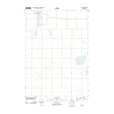
2010 Map of Fulda
USGS Topo · Published 2010About this map
Fulda serves as the primary hub of this Murray County landscape, situated at the confluence of the Fulda Second Lake and Fulda First Lake. The town's grid, including W Front St and the Fulda Post Office, is oriented toward the water, where the Fulda Lake Dam regulates the local flow. This 2010 survey reveals a countryside dominated by a strict section-line road network, where long stretches of Read Ave and Town Ave connect isolated farmsteads across the prairie.
Find a feature on this map
33 named features on this map. Tap any name to fly to it.
Don’t see what you’re looking for? This feature index may not catch every label — zoom into the map to look around manually.
Map Details
Editions of this 2010 Fulda Map
This is the sole edition of this map. No revisions or reprints were ever made.
Other maps of this area

1954 · Fairmont
USGS Topo · 1:250,000

1958 · Fairmont
USGS Topo · 1:250,000

1960 · Brewster
USGS Topo · 1:24,000

1960 · Reading
USGS Topo · 1:24,000

1960 · Worthington North
USGS Topo · 1:24,000

1970 · Heron Lake NW
USGS Topo · 1:24,000

1970 · Dundee
USGS Topo · 1:24,000

1970 · Fulda
USGS Topo · 1:24,000
1970 · Fulda SW
USGS Topo · 1:24,000
1970 · Lime Creek
USGS Topo · 1:24,000