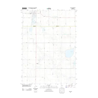
2013 Map of Fulda
USGS Topo · Published 2013About this map
The town of Fulda serves as the primary hub in this southwestern Minnesota landscape, situated at the edge of the elevated Coteau des Prairies plateau. The area is defined by its significant prairie lakes, including the connected Fulda First Lake and Fulda Second Lake, as well as the larger West Graham Lake and East Graham Lake to the southeast. These water bodies, along with the meandering Jack Cr, are set within a strictly gridded agricultural section-line road system that marks the transition between Murray and Nobles counties. The presence of Judicial Ditch Number Twentysix illustrates the historical and ongoing management of the region's hydrology to support its intensive farming economy. This survey documents the intersection of natural glacial topography and the rigid human geography of the rural Midwest.
Find a feature on this map
40 named features on this map. Tap any name to fly to it.
Don’t see what you’re looking for? This feature index may not catch every label — zoom into the map to look around manually.
Map Details
Editions of this 2013 Fulda Map
This is the sole edition of this map. No revisions or reprints were ever made.
Other maps of this area

1954 · Fairmont
USGS Topo · 1:250,000

1958 · Fairmont
USGS Topo · 1:250,000

1960 · Brewster
USGS Topo · 1:24,000

1960 · Reading
USGS Topo · 1:24,000

1960 · Worthington North
USGS Topo · 1:24,000

1970 · Heron Lake NW
USGS Topo · 1:24,000

1970 · Dundee
USGS Topo · 1:24,000

1970 · Fulda
USGS Topo · 1:24,000
1970 · Fulda SW
USGS Topo · 1:24,000
1970 · Lime Creek
USGS Topo · 1:24,000