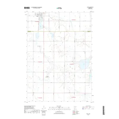
2019 Map of Fulda
USGS Topo · Published 2019About this map
The settlement of Fulda serves as the primary hub in this southwestern Minnesota landscape, situated at the edge of the Coteau des Prairies highland. The terrain is defined by a dense network of glacial lakes and wetlands, most notably Fulda First Lake and Fulda Second Lake adjacent to the town site, and the larger West Graham Lake and East Graham Lake to the southeast. This modern survey illustrates the heavy reliance on agricultural engineering in the region, with Judicial Ditch Number Twentysix and several other managed waterways cutting through the prairie to facilitate drainage. The map provides a clear record of the rectilinear road grid typical of the Great Plains, showing how secondary routes like Co RD 2 and numerous township avenues navigate around the natural depressions and water bodies that characterize this portion of Murray and Nobles Counties.
Find a feature on this map
46 named features on this map. Tap any name to fly to it.
Don’t see what you’re looking for? This feature index may not catch every label — zoom into the map to look around manually.
Map Details
Editions of this 2019 Fulda Map
This is the sole edition of this map. No revisions or reprints were ever made.
Other maps of this area

1954 · Fairmont
USGS Topo · 1:250,000

1958 · Fairmont
USGS Topo · 1:250,000

1960 · Brewster
USGS Topo · 1:24,000

1960 · Reading
USGS Topo · 1:24,000

1960 · Worthington North
USGS Topo · 1:24,000

1970 · Heron Lake NW
USGS Topo · 1:24,000

1970 · Dundee
USGS Topo · 1:24,000

1970 · Fulda
USGS Topo · 1:24,000
1970 · Fulda SW
USGS Topo · 1:24,000
1970 · Lime Creek
USGS Topo · 1:24,000