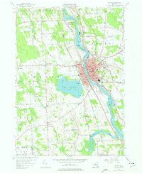
1955 Map of Fulton
USGS Topo · Published 1977About this map
The Oswego River serves as the industrial and geographic spine of this mid-century portrait of Fulton, where the city's dense street grid is anchored by a remarkable concentration of neighborhood schools, including Walradt St Sch, Phillips St Sch, and State St Sch. To the west, the expansive Lake Neatahwanta provides a natural boundary for the city, featuring Stevenson Beach and the municipal Waterworks. The surrounding landscape of Granby and Volney is defined by a traditional rural economy of crossroad hamlets like Lewis Corners and Bowens Corners. Local transport networks are heavily represented by the Delaware Lackawanna and Western and New York Central railroads, which parallel the river and canal. Genealogists will find significant detail in the numerous rural schoolhouses, such as School No 12 and School No 14, alongside established burial grounds like St Marys Cemetery.
Find a feature on this map
77 named features on this map. Tap any name to fly to it.
Don’t see what you’re looking for? This feature index may not catch every label — zoom into the map to look around manually.
Map Details
Editions of this 1955 Fulton Map
4 editions found
Other maps of this area

1900 · Baldwinsville
USGS Topo · 1:62,500

1900 · Oswego
USGS Topo · 1:62,500

1900 · Fulton
USGS Topo · 1:62,500

1902 · Weedsport
USGS Topo · 1:62,500

1943 · Oswego East
USGS Topo · 1:31,680

1943 · Lysander
USGS Topo · 1:31,680

1943 · New Haven
USGS Topo · 1:31,680

1943 · Oswego West
USGS Topo · 1:31,680

1943 · Cato
USGS Topo · 1:31,680

1943 · Pennellville
USGS Topo · 1:31,680