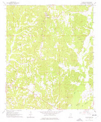
1965 Map of Fulton SE
USGS Topo · Published 1977About this map
The ridge-and-creek country of Itawamba County is defined by a dense network of family cemeteries and rural congregations in the mid-1960s. High ground at Fairview is marked by the Fairview Lookout Tower, providing a vantage point over the dissected landscape where Cummings Creek and Dulaney Branch begin their descent toward the southwest. The area's social fabric is visible in the numerous small churches like Mt Gilead Ch and Union Chapel, often situated alongside burial grounds like the Mt Gilead Ch Cem or Martin Cem. The eastern portion of Fulton appears near the western map edge, with East Fulton and Itawamba Memorial Gardens marking the transition from the town center to the surrounding countryside. This survey captures a moment of local transit and industry, featuring a pipeline corridor and active Gravel Pits near Bull Mountain Creek in the southeast.
Find a feature on this map
35 named features on this map. Tap any name to fly to it.
Don’t see what you’re looking for? This feature index may not catch every label — zoom into the map to look around manually.
Map Details
Editions of this 1965 Fulton SE Map
2 editions found
Other maps of this area

1936 · Red Bay
USGS Topo · 1:24,000

1951 · Red Bay
USGS Topo · 1:24,000

1956 · Tupelo
USGS Topo · 1:250,000

1958 · Tupelo
USGS Topo · 1:250,000

1965 · Fulton SE
USGS Topo · 1:24,000

1965 · Fulton
USGS Topo · 1:24,000
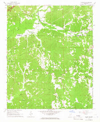
1965 · Fulton NE
USGS Topo · 1:24,000

1965 · Kirkville
USGS Topo · 1:24,000

1966 · Beans Ferry
USGS Topo · 1:24,000

1966 · Tremont
USGS Topo · 1:24,000