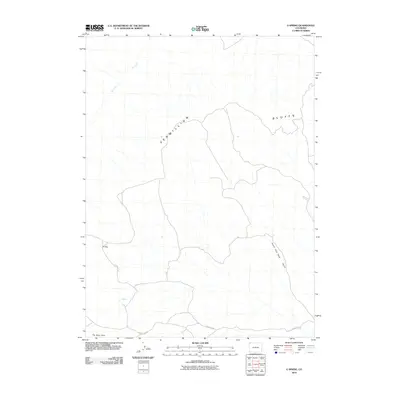
2010 Map of G Spring
USGS Topo · Published 2010About this map
Vermillion Bluffs dominates the northern landscape of this Moffat County high-desert region, where the terrain is defined by dramatic geological breaks and seasonal watercourses. The namesake G Spring serves as a critical water source in an otherwise arid environment, located near the southern boundary along County Rd 52. This route provides the primary access through the territory, passing beneath the prominent landmark known as The Bears Ears.
Find a feature on this map
7 named features on this map. Tap any name to fly to it.
Don’t see what you’re looking for? This feature index may not catch every label — zoom into the map to look around manually.
Map Details
Editions of this 2010 G Spring Map
This is the sole edition of this map. No revisions or reprints were ever made.
Other maps of this area

1954 · Vernal
USGS Topo · 1:250,000

1958 · Vernal
USGS Topo · 1:250,000

1960 · Vernal
USGS Topo · 1:250,000

1960 · Lone Mountain
USGS Topo · 1:62,500

1966 · G Spring
USGS Topo · 1:24,000

1966 · Sugarloaf Butte
USGS Topo · 1:24,000

1966 · Irish Canyon
USGS Topo · 1:24,000

1966 · Sheephead Basin
USGS Topo · 1:24,000

1966 · Hiawatha
USGS Topo · 1:24,000
1966 · Vermillion Mesa
USGS Topo · 1:24,000