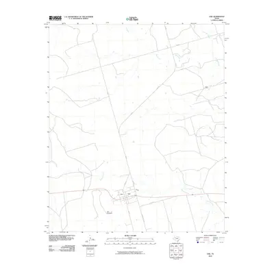
2010 Map of Gail
USGS Topo · Published 2010About this map
Gail serves as the focal point of this West Texas landscape, situated at the base of the prominent Gail Mountain. The settlement pattern is defined by the intersection of FM 669 and local routes like Oak St and Cherry St, transitioning quickly into the ranching country of the Llano Estacado. The hydrology is dominated by intermittent drainage systems, notably Mesquite Creek and the meandering path of Bull Creek, which thread through the open terrain north of the town center. The presence of the Flying D Ranch to the northeast underscores the area's agricultural character. This survey illustrates how the local road network, including Willow Valley Rd and Co Rd 301, follows the natural contours of the land, providing a clear record of the region's rural infrastructure and land use near the start of the twenty-first century.
Find a feature on this map
14 named features on this map. Tap any name to fly to it.
Don’t see what you’re looking for? This feature index may not catch every label — zoom into the map to look around manually.
Map Details
Editions of this 2010 Gail Map
This is the sole edition of this map. No revisions or reprints were ever made.
Other maps of this area

1954 · Big Spring
USGS Topo · 1:250,000

1958 · Big Spring
USGS Topo · 1:250,000

1969 · Gail NE
USGS Topo · 1:24,000

1969 · Beal Hollow
USGS Topo · 1:24,000

1969 · Indian Canyon NE
USGS Topo · 1:24,000

1969 · Gail
USGS Topo · 1:24,000

1969 · Holloway Canyon
USGS Topo · 1:24,000
1969 · Fivemile Creek
USGS Topo · 1:24,000

1970 · Mushaway Peak
USGS Topo · 1:24,000
1970 · Gunsight Draw NE
USGS Topo · 1:24,000