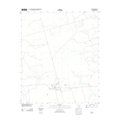
2012 Map of Gail
USGS Topo · Published 2012About this map
Gail serves as the focal point of this Borden County landscape, situated at the base of the prominent Gail Mtn. This survey captures the town's grid during the early 21st century, including local thoroughfares like E Kincaid Ave and Cemetary Rd, while the surrounding ranching country is defined by wide expanses and intermittent watercourses. The drainage patterns of the Llano Estacado are clearly visible through the winding paths of Bull Cr and Mesquite Cr, which carve through the terrain near landmarks such as Town Draw. Beyond the town limits, the map traces the network of rural roads that connect remote holdings like the Flying D Ranch. This map provides researchers with a detailed layout of this Texas county seat, highlighting the intersection of human settlement and the characteristic topography of the High Plains.
Find a feature on this map
25 named features on this map. Tap any name to fly to it.
Don’t see what you’re looking for? This feature index may not catch every label — zoom into the map to look around manually.
Map Details
Editions of this 2012 Gail Map
This is the sole edition of this map. No revisions or reprints were ever made.
Other maps of this area

1954 · Big Spring
USGS Topo · 1:250,000

1958 · Big Spring
USGS Topo · 1:250,000

1969 · Gail NE
USGS Topo · 1:24,000

1969 · Beal Hollow
USGS Topo · 1:24,000

1969 · Indian Canyon NE
USGS Topo · 1:24,000

1969 · Gail
USGS Topo · 1:24,000

1969 · Holloway Canyon
USGS Topo · 1:24,000
1969 · Fivemile Creek
USGS Topo · 1:24,000

1970 · Mushaway Peak
USGS Topo · 1:24,000
1970 · Gunsight Draw NE
USGS Topo · 1:24,000