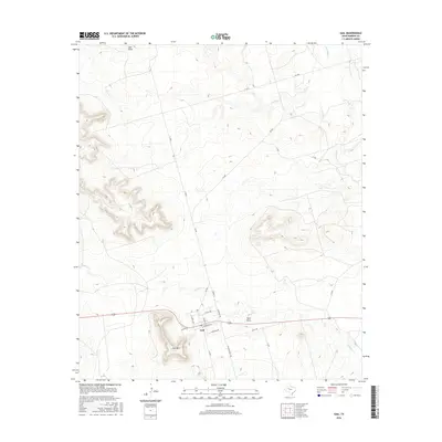
2016 Map of Gail
USGS Topo · Published 2016About this map
Gail serves as a small but vital hub in the high plains of Borden County, dominated by the prominent elevation of Gail Mtn to the southwest. This 2016 survey illustrates a traditional grid-pattern settlement centered at the intersection of FM 669 and Highway 180, where local streets like N Maple Ave and E Dow Ave define the town's core. The surrounding landscape is etched by a series of intermittent waterways, including the winding Mesquite Cr and the geographically significant Town Draw and Salt Draw. The street network, featuring Cemetery Rd and Willow Valley Rd, suggests a long-established rural community where the terrain and water courses have dictated road placement and land use for generations. To the north, the drainage basins of Bull Cr and Little Bull Cr further define the geography of this Texas Panhandle region.
Find a feature on this map
24 named features on this map. Tap any name to fly to it.
Don’t see what you’re looking for? This feature index may not catch every label — zoom into the map to look around manually.
Map Details
Editions of this 2016 Gail Map
This is the sole edition of this map. No revisions or reprints were ever made.
Other maps of this area

1954 · Big Spring
USGS Topo · 1:250,000

1958 · Big Spring
USGS Topo · 1:250,000

1969 · Gail NE
USGS Topo · 1:24,000

1969 · Beal Hollow
USGS Topo · 1:24,000

1969 · Indian Canyon NE
USGS Topo · 1:24,000

1969 · Gail
USGS Topo · 1:24,000

1969 · Holloway Canyon
USGS Topo · 1:24,000
1969 · Fivemile Creek
USGS Topo · 1:24,000

1970 · Mushaway Peak
USGS Topo · 1:24,000
1970 · Gunsight Draw NE
USGS Topo · 1:24,000