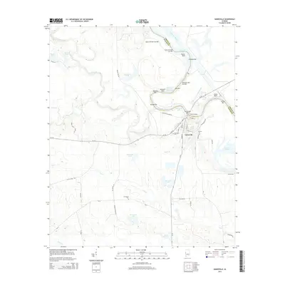
2014 Map of Gainesville
USGS Topo · Published 2014About this map
Gainesville occupies a strategic position at the confluence of the Noxubee River and the Tombigbee River, serving as a central point in this 2014 survey. The town's grid is preserved through named streets like Yankee St and State St, while its deep community history is anchored by the Odd Fellows Cem and the Old Cem. The landscape is dominated by the modern Tennessee-Tombigbee Waterway, which has reshaped the river bends into features like Gainesville Lake and Demopolis Lake. The presence of numerous river bars and bluffs, such as Whitsitts Old Ford Bar and Cherry Bluff, indicates the long-standing importance of river navigation and crossing points in Sumter County. Further inland, the map details a rural geography marked by scattered family-named ponds and lakes including Buchannon Lake and Norwoods Pond.
Find a feature on this map
64 named features on this map. Tap any name to fly to it.
Don’t see what you’re looking for? This feature index may not catch every label — zoom into the map to look around manually.
Map Details
Editions of this 2014 Gainesville Map
This is the sole edition of this map. No revisions or reprints were ever made.
Other maps of this area

1929 · Epes
USGS Topo · 1:48,000

1932 · Epes
USGS Topo · 1:62,500

1953 · Meridian
USGS Topo · 1:250,000

1957 · Meridian
USGS Topo · 1:250,000

1965 · Meridian
USGS Topo · 1:250,000
1970 · West Greene
USGS Topo · 1:24,000
1970 · Boligee
USGS Topo · 1:24,000

1970 · Gainesville
USGS Topo · 1:24,000

1970 · Warsaw
USGS Topo · 1:24,000

1973 · Panola
USGS Topo · 1:24,000