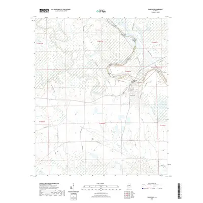
2020 Map of Gainesville
USGS Topo · Published 2020About this map
Gainesville occupies a prominent position at the confluence of the Noxubee River and the Tennessee-Tombigbee Waterway along the border of Sumter and Greene counties. This landscape is defined by its complex river systems and numerous sandbars and bluffs, including Whitsetts Bluff and Cherry Bluff. The river-based geography is marked by distinctive features such as Upper Chicken Cock Bar, Nubbin Bend, and Swilleys Bend, illustrating the shifting course of the local waterways.
Find a feature on this map
62 named features on this map. Tap any name to fly to it.
Don’t see what you’re looking for? This feature index may not catch every label — zoom into the map to look around manually.
Map Details
Editions of this 2020 Gainesville Map
This is the sole edition of this map. No revisions or reprints were ever made.
Other maps of this area

1929 · Epes
USGS Topo · 1:48,000

1932 · Epes
USGS Topo · 1:62,500

1953 · Meridian
USGS Topo · 1:250,000

1957 · Meridian
USGS Topo · 1:250,000

1965 · Meridian
USGS Topo · 1:250,000
1970 · West Greene
USGS Topo · 1:24,000
1970 · Boligee
USGS Topo · 1:24,000

1970 · Gainesville
USGS Topo · 1:24,000

1970 · Warsaw
USGS Topo · 1:24,000

1973 · Panola
USGS Topo · 1:24,000