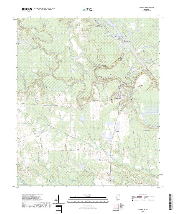
2024 Map of Gainesville
USGS Topo · Published 2024About this map
Gainesville sits at a strategic bend where the Noxubee River meets the Tombigbee River, a landscape defined by the convergence of major waterways and the modern Tennessee-Tombigbee Waterway. This 2024 survey captures the intricate river geography of the Sumter and Greene County border, featuring numerous river bars and landings such as Upper Chicken Cock Bar and Whitsetts Old Ford Bar. Local history and genealogy are anchored by several burial grounds, including Odd Fellows Cem and the Old Cem near Folsom Branch. The map preserves the locations of historical river crossings like Whitsitts Ferry and Gainesville Ferry, illustrating how the community once interacted with the river before modern bridges. South of the main settlement, the land transitions into timber and wetlands, marked by Cypress Swamp and Hill Ranch, reflecting the enduring rural character of this West Alabama region.
Find a feature on this map
71 named features on this map. Tap any name to fly to it.
Don’t see what you’re looking for? This feature index may not catch every label — zoom into the map to look around manually.
Map Details
Editions of this 2024 Gainesville Map
This is the sole edition of this map. No revisions or reprints were ever made.
Other maps of this area

1929 · Epes
USGS Topo · 1:48,000

1932 · Epes
USGS Topo · 1:62,500

1953 · Meridian
USGS Topo · 1:250,000

1957 · Meridian
USGS Topo · 1:250,000

1965 · Meridian
USGS Topo · 1:250,000
1970 · West Greene
USGS Topo · 1:24,000
1970 · Boligee
USGS Topo · 1:24,000

1970 · Gainesville
USGS Topo · 1:24,000

1970 · Warsaw
USGS Topo · 1:24,000

1973 · Panola
USGS Topo · 1:24,000