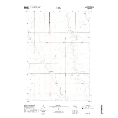
2020 Map of Galchutt
USGS Topo · Published 2020About this map
Galchutt and Colfax anchor this section of Richland County, where the agricultural grid of the Red River Valley is bisected by the meandering course of the Wild Rice River. The landscape is defined by its extreme flatness and precisely surveyed section lines, which dictate the placement of local thoroughfares like Colfax Ave and Co Rd 6. While the larger settlements are sparse, the presence of Our Saviors Lutheran Cem and Bethany Free Lutheran Cem suggests a long-standing community tied to these specific rural townships. Tributaries such as Pitcairn Cr and Antelope Cr drain the surrounding prairie, illustrating the drainage patterns essential to the region's farming heritage. Smaller named locales like Pitcairn and Enloe appear as quiet points in the vast northern plains, marking the enduring footprint of early twentieth-century settlement patterns in North Dakota.
Find a feature on this map
24 named features on this map. Tap any name to fly to it.
Don’t see what you’re looking for? This feature index may not catch every label — zoom into the map to look around manually.
Map Details
Editions of this 2020 Galchutt Map
This is the sole edition of this map. No revisions or reprints were ever made.
Other maps of this area

1895 · Fargo
USGS Topo · 1:125,000

1897 · Fargo
USGS Topo · 1:125,000

1904 · Wahpeton
USGS Topo · 1:125,000

1953 · Fargo
USGS Topo · 1:250,000

1956 · Fargo
USGS Topo · 1:250,000

1959 · Mooreton NW
USGS Topo · 1:24,000
1959 · Walcott
USGS Topo · 1:24,000

1959 · Christine
USGS Topo · 1:24,000

1960 · Galchutt
USGS Topo · 1:24,000

1960 · Mooreton West
USGS Topo · 1:24,000