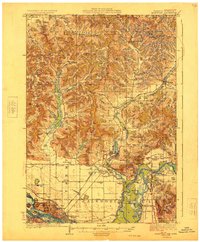
1929 Map of Galesville
USGS Topo · Published 1929About this map
Galesville and the surrounding coulee country of Trempealeau County are captured here during a transitional era of Wisconsin's interior development. The landscape is defined by its complex topography, where deep valleys like Thompson Valley and Norway Valley cut through the high ridges, forcing a settlement pattern that follows the winding creek beds. This 1920s survey highlights the dense network of rural infrastructure, including numerous one-room schoolhouses like American Valley Sch and South Prairie Sch, alongside early sanatoriums such as Wayside San.
Find a feature on this map
88 named features on this map. Tap any name to fly to it.
Don’t see what you’re looking for? This feature index may not catch every label — zoom into the map to look around manually.
Map Details
Editions of this 1929 Galesville Map
2 editions found
Other maps of this area

1926 · North Bend
USGS Topo · 1:62,500

1926 · Whitehall
USGS Topo · 1:62,500

1927 · Blair
USGS Topo · 1:62,500

1927 · La Crosse
USGS Topo · 1:62,500

1929 · Whitehall
USGS Topo · 1:62,500

1929 · Fountain City
USGS Topo · 1:62,500

1929 · Galesville
USGS Topo · 1:62,500

1929 · North Bend
USGS Topo · 1:62,500

1930 · La Crescent
USGS Topo · 1:62,500

1930 · La Crosse
USGS Topo · 1:62,500